Friday, June 24, 2011

Trail 090 Following North Oak Brush Creek

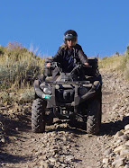
Typical trail near Vernon Reservoir

Old Mining Equipment on Trail 090 Near Vernon Reservoir
Panorama above old mine on Trail 090 West of Vernon Reservoir

Panorama above old mine near North Oak Brush Creek on Trail 090

Rocky outcropping looking east toward Wasatch Mountains on Trail 090

Even More Flora Near Vernon Reservoir

Larkspur Delphinium
nuttallianum

Longstalk Spring Parsley Cymopterus longipes

Nuttall's Violet Viola nuttallii

Pale Agoseris Agoseris glauca

Phlox

More Flora Near Vernon Reservoir

Tufted Evening Primrose oenthera caespitosa

Scarlet Gilia ipomopsis aggregata

Silvery Lupine lupinus argenteus


Uinta Groundsel Senecio multilobatus

Yellow Salsify tragopogon dubius

Flora surrounding Vernon Reservoir

Buckwheat Eriogonum ovalifolium

Glacier Lily Erythronium grandiflorum

Globemallow Sphaeralcea coccinea

Colorful Indian Paintbrush, Larkspur and Phlox
Armed Prickly Poppy Argemone munita

Vernon Reservoir June 16, 2011

About a mile south of Vernon Reservoir near the main rood (Road 005) is a red-colored hill that my husband tried out.

Ascending Hill
Descending Hill
Bitterbrush Purshia tridentata

Chokecherry Prunus virginiana

Vernon Reservoir Utah Maps

There are many trails to follow in the Vernon Reservoir area. This map shows the terrain and a couple of the trails we followed. The trails range from easy to difficult. The balloon shows where the old mine was. The trail above this was blocked by an aspen tree that had fallen over the road. This canyon trail was somewhat steep and rocky, so use caution when riding.


View Vernon Reservoir in a larger map
2008 Motor Vehicle Use Map

Vernon Reservoir

Here are some pictures of the area.

Arrowleaf Balsamroot Balsamorhiza sagittata
Asteraceae - Sunflower
Milkvetch Astralagus scopulorum?
Milkvetch Astragalus alpinus?

June 15, 2011 Visit to Vernon Reservoir, Utah

Vernon Reservoir is approximately 76 miles south of Salt Lake City. Take I-80 west, exit toward Stansbury Tooele (exit 99) on Highway 36. Go approximately 52 miles to Vernon Reservoir.

Vernon Reservoir Campground
This is a small reservoir, no motor boats allowed, fishing permitted. The campground is free. Two restrooms, primitive camping. 10 single sites, 1 group site. The elevation is approximately 6500 ft.

Sunset at Vernon Campground
This is part of the Uinta-Wasatch-Cache National Forest, Spanish Fork District. For a link to that page, click here: Vernon Reservoir Forest Service