Showing posts with label vernon reservoir. Show all posts

Friday, June 24, 2011

Trail 090 Following North Oak Brush Creek

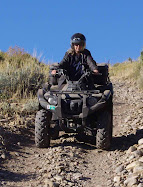
Typical trail near Vernon Reservoir

Old Mining Equipment on Trail 090 Near Vernon Reservoir
Panorama above old mine on Trail 090 West of Vernon Reservoir

Panorama above old mine near North Oak Brush Creek on Trail 090

Rocky outcropping looking east toward Wasatch Mountains on Trail 090

Vernon Reservoir June 16, 2011

About a mile south of Vernon Reservoir near the main rood (Road 005) is a red-colored hill that my husband tried out.

Ascending Hill
Descending Hill
Bitterbrush Purshia tridentata

Chokecherry Prunus virginiana

June 15, 2011 Visit to Vernon Reservoir, Utah

Vernon Reservoir is approximately 76 miles south of Salt Lake City. Take I-80 west, exit toward Stansbury Tooele (exit 99) on Highway 36. Go approximately 52 miles to Vernon Reservoir.

Vernon Reservoir Campground
This is a small reservoir, no motor boats allowed, fishing permitted. The campground is free. Two restrooms, primitive camping. 10 single sites, 1 group site. The elevation is approximately 6500 ft.

Sunset at Vernon Campground
This is part of the Uinta-Wasatch-Cache National Forest, Spanish Fork District. For a link to that page, click here: Vernon Reservoir Forest Service