Saturday, August 23, 2014

July 31 through Aug 3, 2014 Visit to Lake Canyon Campground

We took a few pictures of some of the campsites at Lake Canyon Campground, but first we'll show the map of the area again.

Lake Canyon Campground ATV map (Formerly Miller Flat Campground)

Lake Canyon Campground Site 1

Lake Canyon Campground Site 6

Lake Canyon Campground Site 7

Lake Canyon Campground Site 8

Lake Canyon Campground Site 9

Lake Canyon Campground Site 10

Lake Canyon Campground Site 11 entrance

Lake Canyon Campground Site 11 Fire Pit

Lake Canyon Campground Site 12

Monday, May 21, 2012

May 15 Visit to Little Moab Utah Flower Photo

I found this flower on the way into Little Moab, not far from Redwood Road. It was growing on some sand dunes and because of the bright red, it caught my eye immediately. The plants were almost covering the dunes.

Rumex venosus Large-valve Dock

Sunday, May 20, 2012

May 15, 2012 Visit to Little Moab, Utah Area

Little Moab, Utah is located south of Saratoga Springs and north of Elberta. Get there on Highway 68 (Redwood Road). According to Google Maps, the dirt road leading to Little Moab from Highway 68 is located at 40 degrees 03'16.73" N 111 degrees 57'30.33 W.

This is what the turnoff looks like from Redwood Rd (Highway 68):

Road going west from Redwood Road (Highway 68) leading to Little Moab
There is a brown house back away from the road to the west. The map shows that this road is 9600 South Street, although there are no street signs. We traveled west about 4.5 miles on this dirt road and parked near Chimney Rock. There was a wide place to park vehicles here and we unloaded the ATVs.

Chimney Rock Panorama
 Here is a Google map of the area: Click on the markers; they explain where the photos were taken.


View
Little Moab, Utah Area in a larger map

The upper marker shows the main area considered Little Moab. Off-road jeeps come here to scale the rocks. The next marker down shows Chimney Rock, where we parked. The blue paths show where we took the ATVs. The third marker shows the steep hill my husband climbed, and the bottom marker shows where we photographed the next photo below.

View of Mt. Timpanogos and South end of Utah Lake from old mine

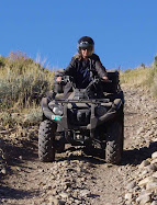
Steep ATV Trail View from Chimney Rock Pass

Tuesday, October 4, 2011

Monk's Hollow Utah ATV Trail

More pictures of Monk's Hollow Utah Trail.

Monk's Hollow Trailhead Parking Lot
 Vault Toilets are available at the trailhead.
Monk's Hollow Group Picnic Sign

Vista of Red and White Hills
The red and white hills near the trail head remind me of the brilliant colored hills in Grand Staircase Escalante National Monument.
Sumac or Skunkbush also known as squawbush Rhus trilobata

Monk's Hollow, Utah Vistas

September 27 was the perfect time to see the fall colors of the maples in Monk's Hollow Area.

Breathtaking Panorama of Monk's Hollow Vista

Bigtooth Maple Trees Acer grandidentatum

ATV Trail Through Maples

Monk's Hollow Trail Panorama

Meadow and Brilliant Fall Colors of the Maple Trees

Leaf-strewn Trail 125 Through Monk's Hollow


More about Visit to Monk's Hollow Utah ATV Trail

Motor Vehicle Use Map (MVUM) of Monk's Hollow ATV Trail from the Uinta-Wasatch-Cache National Forests.

MVUM Monk's Hollow ATV Trail

The dotted lines indicate motorcycle only trails. The broken lines (- - -) represent trails open to vehicles 50 inches or less in width. After going over the small ATV gate, there is a gravel road. We followed the road a short distance but came to the motorcycle trail. We turned around, and by the ATV gate, we turned up Trail 126. We began on trail 126 for ATVs. Trails 125 and 318 are labeled as moderately difficult. We started to go on Trail 318 heading to Teat Mountain, but it began with steep rocky rutted switchbacks and we turned around and continued on Trail 125.

Sunday, October 2, 2011

Sept. 27, 2011 Visit to Monk's Hollow ATV Trail

This ATV trail is between Price and Salt Lake City. If coming from Salt Lake Valley, exit I-15 at exit 258 to US-6 toward Price/Manti. Go about 11.5 miles, then turn left onto Diamond Fork Rd. Diamond Campground is about 6 miles up this canyon. Go past Diamond Fork Campground about 1.5 miles, then turn right at sign that reads Diamond Fork Campground Group Site. There is a large parking lot here (A). The trail leads south to Highway 6. The altitude at the trail head is approximately 5332 feet. The trail is steep and rocky and rutted quite badly in some places. The trail ascends to about 7050 feet. We decided to turn around after we went about 8.8 miles (B). The trail ahead looked too steep and rocky to navigate very well. I think we were about 1 mile from Highway 6 when we turned around.


View Larger Map