Friday, June 24, 2011

More Flora Near Vernon Reservoir

Tufted Evening Primrose oenthera caespitosa

Scarlet Gilia ipomopsis aggregata

Silvery Lupine lupinus argenteus


Uinta Groundsel Senecio multilobatus

Yellow Salsify tragopogon dubius

Flora surrounding Vernon Reservoir

Buckwheat Eriogonum ovalifolium

Glacier Lily Erythronium grandiflorum

Globemallow Sphaeralcea coccinea

Colorful Indian Paintbrush, Larkspur and Phlox
Armed Prickly Poppy Argemone munita

Vernon Reservoir June 16, 2011

About a mile south of Vernon Reservoir near the main rood (Road 005) is a red-colored hill that my husband tried out.

Ascending Hill
Descending Hill
Bitterbrush Purshia tridentata

Chokecherry Prunus virginiana

Vernon Reservoir Utah Maps

There are many trails to follow in the Vernon Reservoir area. This map shows the terrain and a couple of the trails we followed. The trails range from easy to difficult. The balloon shows where the old mine was. The trail above this was blocked by an aspen tree that had fallen over the road. This canyon trail was somewhat steep and rocky, so use caution when riding.


View Vernon Reservoir in a larger map
2008 Motor Vehicle Use Map

Vernon Reservoir

Here are some pictures of the area.

Arrowleaf Balsamroot Balsamorhiza sagittata
Asteraceae - Sunflower
Milkvetch Astralagus scopulorum?
Milkvetch Astragalus alpinus?

June 15, 2011 Visit to Vernon Reservoir, Utah

Vernon Reservoir is approximately 76 miles south of Salt Lake City. Take I-80 west, exit toward Stansbury Tooele (exit 99) on Highway 36. Go approximately 52 miles to Vernon Reservoir.

Vernon Reservoir Campground
This is a small reservoir, no motor boats allowed, fishing permitted. The campground is free. Two restrooms, primitive camping. 10 single sites, 1 group site. The elevation is approximately 6500 ft.

Sunset at Vernon Campground
This is part of the Uinta-Wasatch-Cache National Forest, Spanish Fork District. For a link to that page, click here: Vernon Reservoir Forest Service

Friday, March 11, 2011

March 10, 2011 Visit to Little Sahara Recreation Area

Little Sahara is approximately 115 miles south of Salt Lake City. It is 28 miles west of Nephi. Click here for more information about it: Little Sahara Recreation Area

Little Sahara consists of 60,000 acres of sagebrush flats, juniper covered hills and sand dunes. Sand Mountain is in the southern section. The base elevation is 4800 ft. and it rises to 5471 ft.
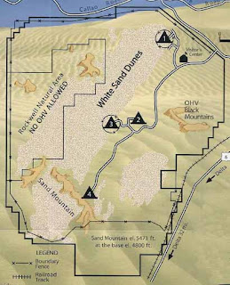
Little Sahara Recreation Area Map
There are four campgrounds with drinking water and flushable toilets in the warm months. In the winter, vault toilets only are available. The visitor's center is open year around. When we visited, the sign said it was closed on Tuesdays and Wednesdays.

Dispersed camping is permitted throughout Little Sahara Recreation Area, but please "leave no trace."

Day use fee was $18.00 for one night, checkout was at 2:00 p.m. A permit good for a year is $120.00

The trails range from easy to very difficult. Whip flags must be used.

View from Sand Mountain looking southwest toward Delta
View from Sand Mountain looking northeast toward
primitive campground/staging area