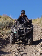
This ATV trail is between Price and Salt Lake City. If coming from Salt Lake Valley, exit I-15 at exit 258 to US-6 toward Price/Manti. Go about 11.5 miles, then turn left onto Diamond Fork Rd. Diamond Campground is about 6 miles up this canyon. Go past Diamond Fork Campground about 1.5 miles, then turn right at sign that reads Diamond Fork Campground Group Site. There is a large parking lot here (A). The trail leads south to Highway 6. The altitude at the trail head is approximately 5332 feet. The trail is steep and rocky and rutted quite badly in some places. The trail ascends to about 7050 feet. We decided to turn around after we went about 8.8 miles (B). The trail ahead looked too steep and rocky to navigate very well. I think we were about 1 mile from Highway 6 when we turned around.
View Larger Map
Sunday, October 2, 2011

Lake Canyon Recreation Area Utah
 |
| 2 Deer in Lake Canyon Campground |
 |
| Huntington Reservoir from Skyline Drive |
 |
| Huntington Mammoth sign |
 |
| Huntington Reservoir |
 |
| Mount Pleasant from Skyline Drive |
 |
| Rolfson Reservoir |
 |
| Rolfson Reservoir |
 |
| Skyline Drive Ridge |
 |
| Skyline Drive Wildflowers |
 |
| Trail 12 Near Huntington Reservoir |
 |
| Typical ATV Trail in Lake Canyon Campground |
Lake Canyon Recreation Area, Utah, More Flora
More Flowers near Lake Canyon
 |
| Rhexia Leaf Paintbrush Castilleja rhexiifolia |
 |
| Rocky Mountain Penstemon Penstemon strictus |
 |
| Showy Daisy Erigeron speciosus |
 |
| Shrubby Cinquefoil Potentilla fruticosa |
 |
| Wallflower Erysimum asperum |
 |
| Western Coneflower Rudbeckia occidentalis |
Lake Canyon Recreation Area, Utah
Lake Canyon Flora
 |
| Alpine Buttercup Ranunculus adoneus |
 |
| Cow Parsnip Heracleum lanatum |
 |
| False Hellebore Veratrum californicum |
 | |
| Lion's Beard Clematus hirsutissima |
 |
| Nootka Rose Rosa nutkana |
 |
| Orange Sneezeweed Hymenoxys hoopesii |
 |
| Penstemon |
 |
| Pretty Jacob's Ladder Polemonium pulcherrimum |
Friday, September 23, 2011
August 10, 2011 Visit to Lake Canyon Campground, Utah
Lake Canyon Campground is located up Fairview Canyon. This was formerly called Miller Flat Campground and is in
Manti-LaSal National Forest. To get there, turn east at 400 North in Fairview, Utah. This turns
into UT-31 E/Canyon Rd. Follow UT-31 about 17 miles. Huntington
Reservoir will be on your right. About 1/2 mile past Huntington
Reservoir will be Miller Flat Road on your right. Turn here. There are
about 46 campsites in this area; 11, 17, 24 and 41 are reservation sites, as well as the group sites Miller Flat, Lake Canyon, and Rolfson Group sites A, B, and C. The other 42 individual sites are first come first served. Long trailers can be parked at
many of these sites. The cost is $5.00 per vehicle. This area is very ATV friendly.
This map shows there are 9.5 miles of ATV trails rated as "easy," meaning the grades are not too steep and the tread surface is relatively smooth. There are 3 learners' loops. When we were there, we tried out the Lake Canyon Learners' Loop and the Rolfson Learner's loop. However, the Rolfson Loop had deep water, probably up to a foot or more deep, in the ruts of the loops. This was definitely not for learners. We got stuck in one of the loops and had to pull the ATV out backwards. Even though it was one-way through the loops, we were forced to go back out the way we'd gone in. Use CAUTION in the loops.
Another dangerous part of the trail was on Trail No. 12 just southeast of Huntington Reservoir. There were deep ruts filled with water here too.
 |
| Lake Canyon Multiple-Use Trail System Map |
Another dangerous part of the trail was on Trail No. 12 just southeast of Huntington Reservoir. There were deep ruts filled with water here too.
 |
| Lake Canyon Campground Site 9 |
 |
| Lake Canyon Campground |
 |
| Stream in Lake Canyon Campground |
 |
| Pond in Lake Canyon Campground |
Friday, June 24, 2011
Trail 090 Following North Oak Brush Creek
 |
| Typical trail near Vernon Reservoir |
 |
| Old Mining Equipment on Trail 090 Near Vernon Reservoir |
 |
| Panorama above old mine on Trail 090 West of Vernon Reservoir |
 |
| Panorama above old mine near North Oak Brush Creek on Trail 090 |
 |
| Rocky outcropping looking east toward Wasatch Mountains on Trail 090 |
Even More Flora Near Vernon Reservoir
 | |
| Larkspur Delphinium nuttallianum |
 |
| Longstalk Spring Parsley Cymopterus longipes |
 |
| Nuttall's Violet Viola nuttallii |
 |
| Pale Agoseris Agoseris glauca |
 |
| Phlox |
Subscribe to:
Posts (Atom)