 |
| Panorama at Five Mile Pass. See Mount Timpanogos on the left. |
View 5 mile pass in a larger map
The top marker shows Eagle Hill. We were just south of the old ghost town of Mercur, Utah. We could see an old mine near Mercur, Utah from this overlook. (Pictured in a later post.) The second blue marker shows where we saw a drill rig next to the trail. The third marker is where the old mine tailings were located. (Again pictured in a later post.)
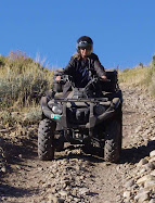
The trails range from easy to very difficult. Many trails follow valleys and some go up and down steep rocky hills. Pick and choose according to your riding ability.
Eagle Hill is over 7,800 feet in elevation. The Staging area is at approximately 5,220 feet elevation.
No comments:
Post a Comment